An automated forest inventory: single trees from the point cloud, whatever the scan type
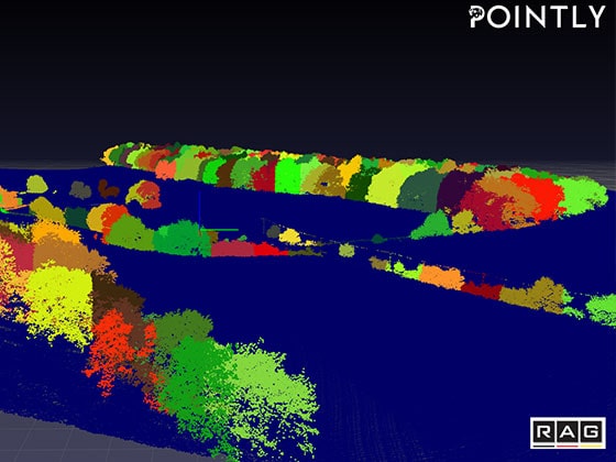
For RAG we automated a forest inventory: LiDAR point clouds become individual trees with object ID, position, height and crown extent – regardless of whether the scan comes from the air or from the ground. The purpose is not counting trees, but isolating causes.
The situation
RAG monitors the consequences of mining over decades – above all landscape change and ground movement. The difficulty is not the measurement but the attribution: a change in the terrain can be a consequence of mining or have an entirely different cause.
This is where the forest inventory comes in. If tree stock, heights and crowns are captured over time, changes that come from the growth or condition of the vegetation can be separated from those caused by ground movement. The inventory is thus an instrument for attributing causes, not a forestry by-product.
The data
LiDAR point clouds from two capture methods: airborne, and terrestrial from the ground. For training, the vegetation first had to be classified by hand.
This groundwork was done in Pointly – with the platform's selection tools it was finished in a few days.
Challenges
Airborne and terrestrial produce different trees. A tree scanned from the air is essentially a crown; the same tree scanned from the ground is essentially a trunk. Methods that need a trunk fail on airborne data, and methods that start from the crown fail in the understorey.
The real requirement was therefore not the highest detection rate on one dataset, but an approach that relies as little as possible on the characteristics of a particular scan type. That is a deliberate decision against over-specialisation – and the reason the method remains applicable to new captures.
Separating single trees where crowns touch. In a closed stand there is no gap between two trees. Where one tree ends and the next begins is a decision that has to be made before anything can be counted.
Approach
Deep learning for classification, geometric methods for separation. A neural network takes over the assignment of which points belong to vegetation. Separation into individual trees works through a combination of tree features such as crown maxima, trunk positions and geospatial algorithms. Several methods were tested for this, among them watershed analysis and region growing from detected trunks.
Keeping both routes open – with and without a visible trunk. The segmentation works for trees with a recognisable trunk and for those where only the crown is present. That is the practical implementation of scan-type independence.
Deriving inventory data per tree. For each tree segment, trunk position and height are determined, the crown extent via a 2D projection.
Exporting to common geodata formats. Classification and instance segmentation are exported to GeoJSON and Esri Shapefile and enriched with attributes such as heights – so the result lands in the environment the department already works in.
Outcome
The proof of concept was successful. The result is two map layers with tree counts, crown shapes and tree heights – not as a report to read, but as a dataset that can be intersected with the other monitoring data.
Transferability
Instance segmentation on point clouds with subsequent attribute derivation is the task wherever it is not an area but the individual objects within it that are to be counted and measured: municipal tree registers, vegetation management along utility corridors and railway lines, tree inventories in orchards, biomass estimation. The methodological core – classify first, then separate, then attribute – stays the same. Today we deliver projects of this kind together with our sister company Pointly as our technology partner.
Continuing development
The method is being continued together with Pointly: new data is being processed on an ongoing basis, with the goal of automating the workflow and offering it as a service on the Pointly platform. In domain terms, the most interesting part is the next step the data now allows: once the same area has been captured several times, growth and loss of vitality can be tracked per individual tree over time – delivering exactly the separation of causes that the monitoring is about.
Last updated: 6 August 2026