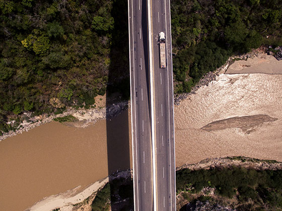
The automatic detection of different trucks in orthophotos with ArcGIS-Pro
Model training requires a large amount of training data to achieve optimal results. For better results and analysis, more training data and better data resolution would have been necessary. For example, the model occasionally recognised cars with trailers (and in rare cases house walls) as trucks. Furthermore, it was difficult to differentiate between two vehicles parked close to each other, as they can be perceived as one vehicle.

A deep learning model was trained for automated recognition and differentiation of the different vehicle types. A pre-trained TernausNet-16 model was used for this purpose. In the case of vehicle detection and classification, the output of the model consists of pixels belonging to the classes background, trailer and cabin. The detected trucks were then divided into 3 classes based on the length of the truck. Subsequently, the trained model and truck classification was implemented in ArcGIS Pro through an inference function and a specific esri model definition file.
The model resulted overall with good and reliable accuracy, precision and recall. Over 99% of the trucks were recognised by the model. Less than 10% of the detected trucks were classified in the wrong class. Further fine-tuning of the model, with additional training data from different conditions, can make the model even more robust.
Other Use Cases in this category
The automated generation of CAD models from 3D highway Use Case lesen
The automatic detection of different trucks in orthophotos with Use Case lesen
The automated conduction of a forest inventory Use Case lesen

